There are areas in Switzerland in which flying drones is prohibited or restricted. Drone pilots must find out about the applicable flight restrictions before each flight.
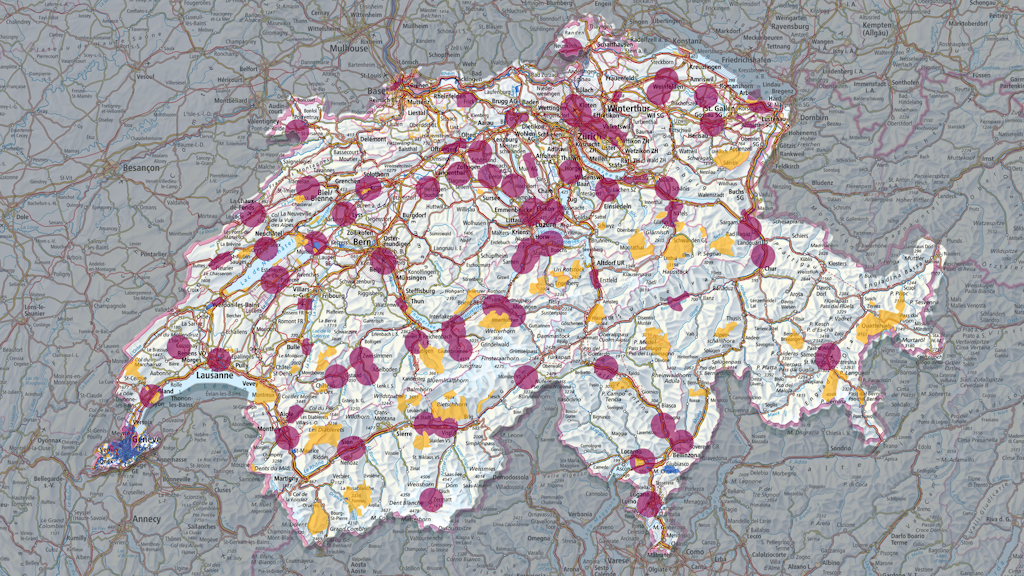
The content of the interactive drone map is constantly modified and must therefore be consulted before each flight. The drone map shows the national and cantonal flight restriction areas.
Drone pilots must contact the competent authority to obtain permission to fly their drone in an area with flight restrictions. The competent authority, along with further information, is displayed by clicking on the respective area on the map. Further information can also be found below.
Interactive drone map
Access the drone map
Control zones (CTR) of aerodromes
Aerodrome perimeters (SIL or SPM perimeter according to sectoral plan)
Prisons
Wildlife protection areas
Nuclear power plants
Military areas
Energy and gas supply infrastructure
Other geographical flight restrictions set by the cantons
Daily Airspace Bulletin Switzerland (DABS)
Example of a DABS from 9th of December 2025
A map of Switzerland showing the main civil aviation reports is published daily on the DABS website. Drone operators must respect any DABS restrictions that affect their planned drone flight. They should therefore consult DABS before each flight.
DABS is updated several times throughout the day. The version for the following day is published daily at 4pm.
Daily Airspace Bulletin Switzerland
Access the DABS
A NOTAM (Notice to Airmen) is a message about an installation, condition or a change in the airspace. DABS displays the most important NOTAMs on a map. Some changes are indicated in DABS only in text form.
Areas with heightened risk of collision
To avoid dangerous proximity to or even collision with other airspace users, particular caution must be exercised when operating drones near to the following areas:
Open the drone map and click on the area in which you wish to fly your drone. This opens the ‘Object information’ window.
Check whether there are flight restrictions in the area (under ‘Designation’) and whether these apply to you (under ‘Restriction’).
You may fly your drone provided no restrictions apply. Otherwise, you require authorisation from the competent authority, which can be found under ‘Further information’.
Open the latest version of DABS. Check whether any flight restrictions apply in the area in which you wish to fly your drone. [1] You may fly your drone provided no restrictions apply. Instructions on understanding DABS can be found below:
Open the maps in the section ‘Areas with heightened risk of collision’ and search for the area in which you wish to fly your drone. If you wish to fly in an area that is close to an area with a heightened risk of collision, you must adapt your flight accordingly.
Example: Special attention must be paid to helicopters in the vicinity of a heliport. If a helicopter approaches, you must land your drone.